Oz in '08 -- Beth and John Lucas Tour Australia, 7
All pictures, unless otherwise noted, are copyright 2008 by John A. and Elizabeth B. Lucas. All rights reserved.
Introduction Sydney Canberra Melbourne Western Victoria Queensland Uluru-Kata Tjuta Notes on the Photos GBCC File Transfers
Sydney, Wednesday June 25th to Friday June 27th
We returned to Sydney for about 48 hours.We attended a performance of My Fair Lady in the Sydney Opera House.
Richard and Joanna Phillips invited us out to dinner the following evening.
In between, we took a harbor cruise, a walk in the gardens and many of the fair weather daytime photographs of Sydney on page 2.
We stayed at the Sir Stamford at Circular Quay on Macquarrie Street, up the hill from the Opera House and across the street from the Gardens. We left most of our luggage with the hotel as we would be returning there after spending three days at Uluru-Kata Tjuta National Park. This made it easier for us to just use the train from Circular Quay as we were only bringing our photography bags and one carry on bag.
Uluru-Kata Tjuta National Park, Friday June 27th to Monday June 30th
Most of you know Uluru as Ayer's Rock. Kata Tjuta used to be called the Olgas. They are about 25 kilometers or so apart in the southwest corner of the Northern Territory near the state lines with Western and South Australia. Both formations were formed at the same time with different results and lie within aboriginal lands and a national park. Uluru is listed twice as a UNESCO World Heritage and Cultural Heritage Site.All visitors, services, and the airport lie outside the park in Yulara Township, reputedly the fourth largest population center in the Northern Territory with about 1200 staff and 6000 or so guests. Accommodations range from camping sites to Longitude 131, which goes for about $2000 a night per person, minimum stay two nights. We stayed at the Pioneer Outback Hotel which was sufficient unto our needs.
John and Beth have wanted to see Uluru for years, even decades. It did not disappoint. Between the two areas, we shot more the 600 pictures in three days to try to capture the changing moods of the place.
Before we start on the pictures, we took five tours in the three days that we were there:
- An Uluru Sunrise tour (AAT Australia)
- A Kata Tjuta Sunset tour with barbecue and star talk (AAT Australia)
- An Uluru Base Walk (starting at sunrise, EcoDiscovery Tours)
- An Uluru Sunset tour with Aboriginal guide (Anangu Tours)
- A two hour light plane charter at sunrise over Uluru, Kata Tjuta, Lake Amadeus and Kings Canyon (Ayers Rock Scenic Flights)
Pictures from the air and of Kata Tjuta on the ground are thus obvious which tours they are from. Most of the resort stirs before sunrise and heads into the park for the dramatic beginnings of the day. As the year gets closer to summer, this gets earlier and earlier (to start times around 4am) but also necessary to avoid the worst of the summer heat. In mid winter these considerations are less important with morning pickups between 6 and 6:30am.
These are pictures that are very dependent upon the color balance of your monitors. At sunrise and sunset, these rocks glow like the embers of a fire.
Uluru (Ayer's Rock)
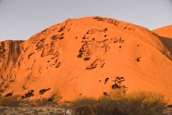
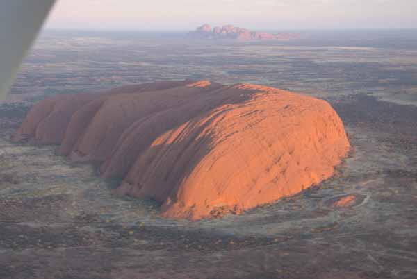
It is BIG and yes it is that red. 1100+ feet above the plain and 5.8 miles in circumference, Uluru is estimated to extend underground 2-3 miles so only about 10% is visible. The base walk is about 6.5 miles as it does not always hug the base of the rock. Uluru is composed of arkose sandstone (which is gray when first exposed to air and water but quickly rusts), tilted to almost 90 degrees, It is pitted is some places forming caves, many of which are Aboriginal sacred sites. At other places it is exfoliating smooth sheets of stone.Sunrise at Uluru.
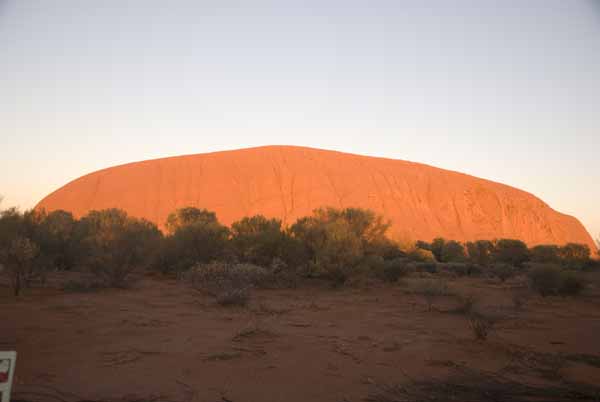
Sunrise at Uluru during the base walk. As you see, the surface is NOT uniform everywhere. The Aboriginal creation stories attach meaning to many of the features. Some sites are sacred to one or the other of the sexes.
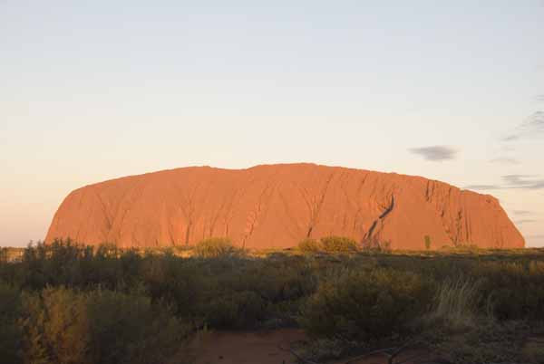
Sunset at Uluru. The buttress for the climb is facing you near the right end.
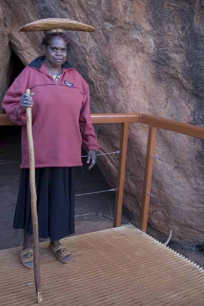
Our Aboriginal guide, Rebbeca, showing how the women carried the "bush tucker" that they gathered. The women in the group were invited to try doing it. The men were not invited. Aboriginal culture clearly defined roles and responsibilities between the sexes as they did the sacred sites.
We experienced a momentary shock as she ducked under railings and walked around the protected sites. But then, SHE is one of the owners of the park. Although some of the sites and discussion of creation stories overlapped one of our other tours, the Aboriginal viewpoint did add to our understanding.
Uluru at sunrise from 4000 feet, Kata Tjuta in the distance and to the southwest.
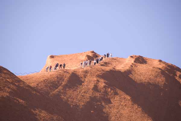
Here is a distance view of a portion of the Uluru climb. The Aborigines ask that people do not climb. It is closed by the park about 200 days a year due excessive heat, wind, rain or special events. It was closed one of the days we were there for high winds. One of the tour guides asserted that two kinds of people climb Uluru -- Japanese who specifically come to climb (in the same spirit as climbing Mt Fujiyama which is regarded as something of a pilgrimage) and Australians. It is asserted that relatively few Europeans or North Americans choose to climb. Several people are injured and need to be airlifted each year and someone dies every few years from falls or heart attacks. Entire busloads of tourists make the ascent -- Australian school groups were singing songs as they went! The crest here is not the end of the climb, though most of the altitude. It takes most people at least an hour to ascend and two to three for the entire trip. According to one guide, the "record" for the ascent is held by a female marathoner who completed the full ascent in 12 minutes. We bet she took a lot longer coming down! Some people do run down (at least the last 50 yards or so), some come down backwards and some come sliding down on their backsides like crabs.
The Aborigines call the climbers minga or black ants and that's what they look like from a distance. The same term could be applied to the tour groups ascending the Sydney Harbor Bridge.
Kata Tjuta (The Olgas)
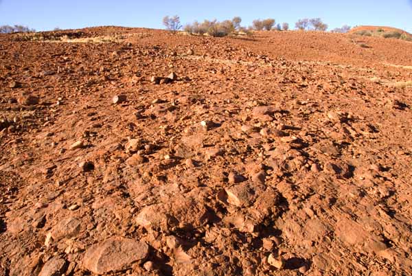
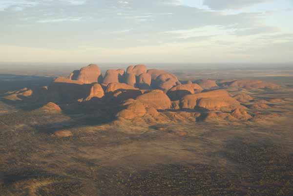
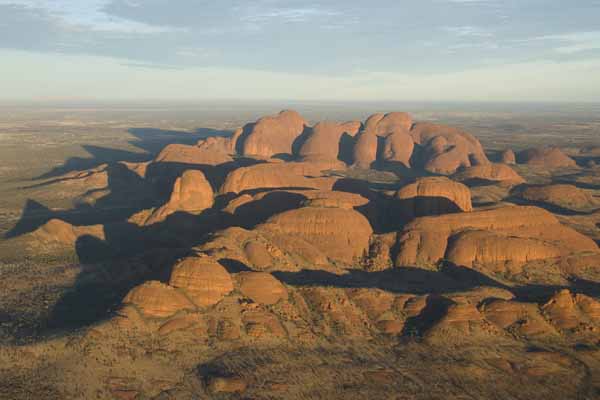
Kata Tjuta is larger at the base and taller (about 1700+ feet above the plain) than Uluru. Although it was formed at the same time, there are differences:- the tilt of the sedimentary beds is around 19 degrees instead of nearly 90 degrees
- the stone is conglomerate of boulders, pebbles and sand
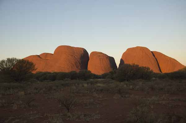
Kata Tjuta at sunset.
4000 feet above Kata Tjuta at sunrise, looking east to Uluru, with Mount Conner 55 miles further east of that.
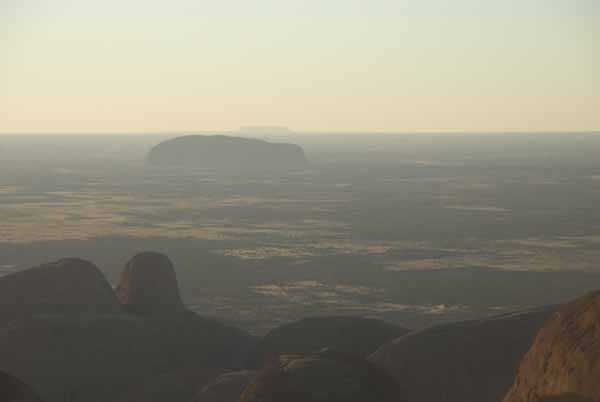
Two aerial views of Kata Tjuta at sunrise.
Lake Amadeus
Lake Amadeus is a 110 mile long salt lake between Uluru and Kings Canyon. Early explorers and present day roads had to detour far to the east to travel to the other side. Our pilot brought us down to 500 feet above the ground, looking for wild camels. We didn't spot any though there were plenty of tracks in evidence.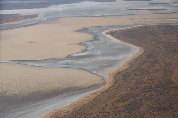
Kings Canyon
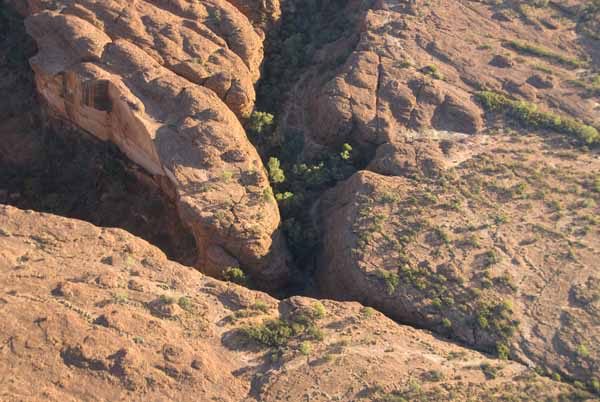
Kings Canyon lies north of Uluru and Lake Amadeus, many many miles by road but about 35 minutes by light plane. The canyon is a right angled gash in the western end of the George Gill Range. With still early morning air and no ceiling, our pilot pointed it out from 100 miles away. With visibilities and weather conditions like that, navigation is pretty easy although radio and navigational aids due exist in the area for the Yulara airport which serves several Boeing 737-sized jets every day.The canyon walls are nearly 1000 feet tall in places. The picture below shows the right angle turn (canyon mouth to the left) and the Garden of Eden.
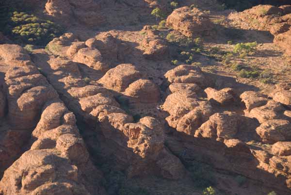
These formations are reminiscent of Kata Tjuta (but much smaller) and the Bungle Bungles in the extreme northeastern corner of Western Australia. Here they are called the City of the Dead. There is a walking tour winding its way among these domes, though they may not be visible in the low resolution images rendered for the web site.
All those aerial shots occurred in the last two hours (except for waiting) we had at Uluru and Kata Tjuta.
Sydney (1st and 2nd)
In early afternoon, we flew back to Sydney for the last time, checked back into Sir Stamford at Circular Quay and reclaimed the rest of our luggage.Some last minute shopping, those night views of Sydney and a farewell fish and chips watching the ferries at Circular Quay summarize our last 36 hours in Australia.
In the morning of the 2nd, we checked out of the hotel, took a pooled shuttle van to the airport and attempted to check into our flight. "Attempted" because it had in fact been cancelled and the prior flight to Los Angeles had already left. (Apparently QANTAS had tried to reach us as early as June 25th through our "agent" QANTAS US, who in turn may have been the two mystery calls John received on his mobile phone at about 3:30 am and failed to answer. With no return number to call, they remained unanswered. Had QANTAS called us directly in Australian time there wouldn't have been a problem.)
In any case, they booked us on a flight to San Francisco and then a connection to Boston. Despite the travail, the new flights actually got us to Boston an hour earlier than we would have arrived by the original flights. After the fact, we learned that our son Alex was passing through the same airport en route to a video shoot at Stanford University. We didn't make contact; none of knew and we weren't even supposed to be at that airport. A small world nonetheless.
Unlike the UK trip we did NOT have an emergency retry of landing and we did arrive home with all of our luggage!
Conclusion
So that's our grand tour to Down Under. Would we do it again? You bet! Could you do it cheaper? Yup -- don't hire helicopters and light planes for your use; stay in hotels away from the city centers and commute as needed (as we did in Melbourne). You won't save on the airfare -- we booked six months in advance avoided the big run up in fuel prices. We booked everything in advance, paying in advance when we could. In a few places, this either got us a discount or one "free" night.Would we do anything differently? Yes. Fraser Island certainly -- we'd allocate TWO days, stay at an on island resort and take short trips spread over those two days, charter a plane at Heron Island for aerial photography too.
At Uluru, we'd skip the base walk tour run by EcoDiscovery Tours. The guide alternatively raced ahead faster than Beth could manage, then stopped to give overlong, preachy lectures that let us stiffen up. Eventually we told the guide we'd keep going and meet the rest at the climb point rendezvous area. We got there at least 30 minutes before they did by maintaining a steady pace, even with stopping to take pictures and read signs. Were we to do it again, we'd use Uluru Express (essentially a taxi service) to drop us off the the climb point at sunrise and pick us up three hours later.
We don't think there'd be much else we'd change except perhaps another day in Canberra to see a few more things. We'd do it again in a flash (and VERY long flights!).